Source: http://www.chinareviewnews.com 2012-07-25 01:05:29
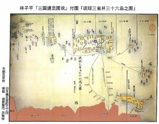
The “Map of Three Provinces and 36 Islands of Ryukyu” attached to
A Comprehensive Map of the Three Countries drawn
by Japanese Lin Tzu-Ping (林子平, 1738-1793)
The “Map of Three Provinces and 36 Islands of Ryukyu” (《琉球三省並三十六島之圖》) attached to A Comprehensive Map of the Three Countries (《三國通覽圖說》) drawn by Japanese Lin Tzu-Ping (林子平, 1738-1793) is an important document at present among the historical records retained by China, Japan, and Ryukyu (Okinawa). It accounts for the Diaoyutai Islands as a Chinese territory. The map was drawn in color, with the Japanese mainland in purple, the Ryukyu Kingdom in brown, and China proper in light red (including the island of Taiwan in dark yellow). On the map, islands and islets like Huapingyu (花瓶嶼), Pengjiashan (彭佳山), Diaoyutai Islands (釣魚台島嶼), Huangweishan (黃尾山), Chiweishan (赤尾山), etc., located between the Fujian Province of China and the Naha Port of Ryukyu, were all marked with the same light-red color as China proper; the implied meaning as Chinese territories is clear and can be understood at a glance without any possibility of misinterpretation.
Exactly for this reason, some Japanese scholars with a militarist ideology have always been reticent about this map and tried to downplay its historical significance. Thus it can be proved conversely that this map of Lin Tzu-Ping is clear evidence that China has owned the Diaoyutai Islands. The subsidiary library of the University of Tokyo in Japan has this map in its collection. I have seen this map personally during my visit as a visiting fellow at the Teaching Department of the Tokyo University. Recently a Japanese friend of mine helped me by borrowing this map and making a color copy of the original map. Although it is a copy, due to the advanced Japanese technology (in the 1990s), this copied map is exactly the same as the original one. It is unlike the imitation made by the Japanese Xiang Xiang Yuan (享香元) in the 19th century.
Therefore, I think the map that I have should enjoy the same significance as the original one. And I think there is a need for a more detailed explanation regarding this map that has an important historical value. A Comprehensive Map of the Three Countries written by Lin Tzu-Ping was first published in the fifth year of the Japanese Tenmei era (天明五年; the reigning emperor was Kokaku-tenno (光格天皇)). Namely, it was published in the autumn of the fiftieth year (1785) of Emperor Qianlong (乾隆) of the Qing Dynasty by the Japanese publisher Suharaya (須原屋) located in the 3rd section of the northbound Muromachi Street, Japan Bridge, Tokyo (東京日本橋北室町三丁目).
A Comprehensive Map of the Three Countries has 5 associated maps: they are separately "A Comprehensive Study of the Three Countries and Their Road Maps" (《三國通覽與地路程全圖》), the "General Map of Ezo" (《蝦夷國全圖》), the "Map of Eight Provinces of the Yi-Dynasty Korea" (《朝鮮八道之圖》), the "Map of More Than 80 Large and Small Uninhabited Islands" (《無人島大小八十餘之圖》) and the "Map of Three Provinces and 36 Islands of Ryukyu." Among them, the "Map of Three Provinces and 36 Islands of Ryukyu" has a vertical dimension of 54.8 cm, and a width of 78.3 cm. The “Map of Three Provinces and 36 Islands of Ryukyu” is in the middle part of the diagram; the lower-left corner has the signature “drawn by Lin Tzu-Ping, Sendai (仙台)” in regular script of small characters (xiaokai, 小揩) as in the Chinese calligraphy exercises. The map draws two sea routes guided by compass from Fuzhou in Fujian Province to Naha in the Ryukyu Islands. The south route is from west to east and marks successively "Huapingshan (Pinnacle, 花瓶山), Pengjia Islet (Agincourt, 彭佳嶼), Diaoyutai, Huangweishan and Chiweishan” with this note next to it: "This sea route takes 40 geng (更, 1 geng = 2 hours) by boat, the distance to Japan is two hundred and forty li (里, 1 li = 0.5 kilometer ;” the north route is from west to east and marks successively "Dinghai Station (定海所), Limashan (里麻山), Taishan (台山), Yushan (魚山), Fengweishan (鳳尾山), Nanqishan (南杞山)" with this note next to it: "This sea route takes 50 geng by boat, the distance to Japan is three hundred li.” These islands are all marked in the same light-red color as China proper (Guangdong, Fujian, Zhejiang, Nanjing and Shandong Provinces).
The lower right corner of the diagram (the southwest corner) shows the Taiwan Islands, including the island of Taiwan, Small Ryukyu (小琉球), Jilongshan (雞籠山), Dongsha (Eastern Islands, 東沙群岛), and twenty-six islets of Penghu (澎湖), etc., in dark-yellow color. The Ryukyu main island as well as Bachongshan Islands (Yaeyama Islands, 八重山群島; a total of eight islands) at the southernmost tip, Gongu Islands (Miyako Islands, 宮古群島; a total of seven outer islands), Qijie Island (Kikai Island, 奇界島 or 喜界島) at the northernmost tip, and Gumishan (姑米山) at the southwest side and the opposite side of Chiweishan are all drawn in brown color.
At the northeast corner of the diagram is Kyushu Island (九州島) of Japan. Together with Qijie Island of the three Ryukyu Kingdoms, Tokara Islands (提噶喇島 or 吐噶喇群岛) on the opposite side of Qijie Island, Hengcong Island, the Peninsula, Zhongzhi Island (Nakanoshima, 中之島), etc. (collectively called the Northern Kyushu Islands), are drawn in green color.
Quite obviously, from the graph coloring, Lin Tzu-Ping set China and the Ryukyu Kingdom border delineation between Chiweishan and Guimishan. This is in agreement with the viewpoint of the Ryukyu scholar Cheng Shunze (Cheng Yoshinori, 程順則). In the cited passages of Cheng’s book A Geographic Guide in Outline (《指南廣義》), Gumishan was "the Chen Hill at the southwest border of Ryukyu" (Chen means to garrison a state frontier or a village border). In the site boundary map of Lin Tzu-Ping, the boundary lines between the countries are very clear. Taking the Ryukyu Kingdom as an example, in the north Qijie Island is the boundary with Japan, in the southwest Gumishan is the boundary with China, while at the southern end the Bachongshan Islands form the boundary with Taiwan. The territorial awareness is very clear. Unlike an article, readers who understand it with different views can argue about it.
Some Japanese scholars with ulterior motives, in order to achieve the purpose of denying China’s ownership of the Diaoyutai Islands, dare not evaluate the map of Lin Tzu-Ping (actually they are afraid to face the facts). Instead, they try to restore history through text (since text has the possibility of being misinterpreted) in an attempt of belittling the value and significance of Lin’s map. For example, the Ryukyu government statement drafted by Aoyuanminxiong (Toshio Okuhara, 奧原敏雄), which was looked up to as a standard by the Japan authorities, declared: "Although A Comprehensive Map of the Three Countries accounted for the Diaoyutai Islands, Huangweiyu, Chiweiyu as Chinese territories, Lin Tzu-Ping also admitted that the book was modeled out of The Zhongshan Mission Records" (《中山傳信錄》) . It declared further: "His map was a patchwork of the ‘Map of the 36 Islands of Ryukyu’ and ‘The Navigation Map’ contained in The Zhongshan Mission Records. He mechanically accounted for the Diaoyutai Islands and Huangweiyu, etc., that were not included in the Ryukyu territory, as Chinese territories and colored them as such. However, even among the messages recorded in ‘The Navigation Map’ of the The Zhongshan Mission Records, there is no evidence that these islands belong to China."
Regarding the above Ryukyu government statement of using text to restore history to mislead and try hard to disparage the drawing of Lin Tzu-Ping, Japan's renowned historian Jingshangqing (Kiyoshi Inoue, 井上清) rebuked: “Although Tzu-Ping said that the drawing he made was based on the map of The Zhongshan Mission Records, he did not make an intact copy without critical examination. To write the main text and draw the map of A Comprehensive Map of the Three Countries, he had studied The Zhongshan Mission Records, as well as A Biographical Sketch of the Ryukyu Kingdom (《琉球國事略》) written by Xinjingbaishi (Arai Hakuseki, 新井白石) who was the most authoritative scholar on Ryukyu research, and other books, etc., of his time, plus his own knowledge. In the maps of The Zhongshan Mission Records, there is no color distinction between different countries, but Lin Tzu-Ping’s map includes color separation.”
In order to demonstrate that the coloring of Lin Tzu-Ping’s map was not done mechanically but was a correct description of the national borders at the time, Professor Inoue went to the Gucun (穀村) Library, a subsidiary library of the Kyoto University, to find two differently colored copies of the “Map of Three Provinces and 36 Islands of Ryukyu” of the Edo period (the same period of Lin Tzu-Ping). In one of the maps, Ryukyu was colored in red, China proper and the Diaoyutai Islands in thin light-brown, Japan in green, Taiwan and Penghu in yellow. However, in the other map, Ryukyu was colored in yellow, China proper and the Diaoyutai Islands in light-red, Taiwan in gray, while Japan was colored in green. Comparing the two maps, it is obvious that Japanese in the Endo period viewed the Diaoyutai Islands as Chinese territory. This was not accidental, but the historical fact at the time.
It can also be proven from this that the map of Lin Tzu-Ping, which placed the Diaoyutai Islands within Chinese territory, has received general recognition in Japan and consensus by the ruling and opposition parties. In addition, there is a modern map drawn by Japanese in the World Geographic Map (《地球與地全圖》), which was a collected edition of Wen Qixuan (溫其軒) and had been proofread and amended by the master Shantianlian (山田聯) of Yongguizai(詠歸齋) in the spring of the Bunka-7th year (1810, 文化 7年) of the Japanese calendar. The "Small Orient" part of this map drew islands along the "China Sea;" in the middle south of Fujian and Ryukyu were drawn Huapingshan, Pangjiashan, Huangweiyu and Chiweiyu, clearly marking the Diaoyutai Islands as Chinese territory. This modern map was basically drawn based on the Lin Tzu-Ping map. It indicates that the geographers of the 19th century in Japan also recognized the Lin Tzu-Ping map.
Lin Tzu-Ping’s A Comprehensive Map of the Three Countries not only was widely circulated in Japan at that time and appeared to have a variety of facsimiles, but also at the same time attracted international attention. In 1832, the famous French Oriental scholar M. J. Klaproth translated the map into French and published it in Paris. The translated original map was also colored, in which the five small islands of the Diaoyutai Islands were marked with the same red color as China proper, while the Ryukyu Islands were marked with yellow color. As far as the Diaoyutai Islands belonging to the Chinese territory, it is also very clear for the Westerners.
It is evident that A Comprehensive Map of the Three Countries and other books written by Lin Tzu-Ping did not result from theories by scholars, but resulted from personal investigations and analysis. Another factor is that Lin Tzu-Ping’s books were written for coastal defense and border protection plans. The tri-border map drawn by him must be extremely precise and error free in order for the authorities’ reference for military defense. Therefore, the value and importance of A Comprehensive Map of the Three Countries by Lin Tzu-Ping are indisputable.
|