Source:http://www.chinareviewnews.com 2012-07-15 00:28:38
The boundaries of the Ryukyu Kingdom and China were divided very clearly since the Ming Dynasty; they were both land boundaries and maritime boundaries.
The Diaoyutai Islands (釣魚台列嶼) that are located on the shallow continental shelf of the East China Sea have always been an inalienable part of Chinese territory since ancient times. No matter whether judging from the viewpoints of historical documents, geographical-geological structure or international theory of law, their territorial integrity and sovereignty belong to China; specifically the evidence is as follows:
(1) Discovery, Denomination and Use
The discovery, denomination and use of the Diaoyutai Islands were first seen in the book of Sail with the Wind (《順風相送》) written in the first year of the reign of Emperor Yongle (1403) of the Chinese Ming Dynasty by envoys who were sent by the imperial court to announce the emperor orders to the Oriental and the Western countries. The book section “Sailing from Fujian to the Ryukyu Islands” records that to survey the route and calibrate the compass the envoys on several occasions went to the Diaoyutai Islands and used these islands as a navigational reference to the Ryukyu Islands. In international law, this has constituted a kind of "Inchoate Title.”
(2) Border Division between China and the Ryukyu Kingdom
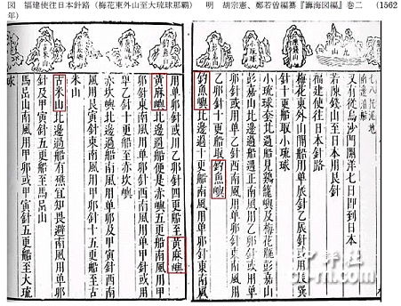
The border divisions between the Ryukyu Kingdom and China were very clear since the Ming Dynasty. These included both land boundaries and maritime boundaries. And these boundaries were formed after actual site visits by envoys sent by the government and with the consent of the other side. The written records on China-Ryukyu boundaries are reflected in the Records of the Imperial Mission to Ryukyu (《使琉球錄》, 1534) by Chen Kan (陳侃), the imperial envoy to Ryukyu: "Gumishan (古米山)belongs to Ryukyu;" the Records of the Imperial Mission to Ryukyu (1562) written by Guo Rulin (郭汝霖) has: "Chiweiyu (赤尾嶼, 赤嶼)is the local hill boarding Ryukyu;" Xu Baoguang (徐葆光)recorded in the Records of Messages from Zhongshan (《中山傳信錄》, 1719): "Gumishan (the Chen Hill at the southwest border of Ryukyu)" (Chen means garrisoning the state frontier or a village boarder). The above three historical documentations clearly record the land boundaries between China and Ryukyu. From the Chinese side, the land boundary was the Chiweiyu; from the Ryukyu side, the land boundary was the Gumishan (the present-day Kumejima Island). The records related to the division of China-Ryukyu maritime boundaries can be seen from the historical document Addendum to Summarized Record of Ryukyu (1579) written by the imperial envoy Xie Jie (謝傑)who was sent to Ryukyu and other related books, in which the sea boundaries of China and Ryukyu were clearly recorded. The dividing line was the black water trench located between the Chiweiyu and the Gumishan (namely the East China Sea Trough with depths to 2700 meters).
The official records mentioned above already meet the classification criteria in relation to the territorial boundary of a State in modern international law.
(3) Time under the Administrative Control of China
The earliest time for the Diaoyutai Islands, the Huangweiyu (黃尾嶼), and the Chiweiyu to become part of the administrative regions of China can be seen from the book Maps and Plans for the Coastal Defense (《籌海圖編》) carved in the Jiajing forty-one year (1562) of the Ming Dynasty. The Supreme Commander Hu Zongxian (胡宗憲) of China’s Anti-Japanese Military Command of the Southeast Coast presided over the writing of the book while Zheng Ruozhen (鄭若曾) edited it. After completion, the Military Command carved the content into wood and published it as a book.
(4) Geographical and Geological Structures of the Diaoyutai Islands
From the geographical point of view, the Diaoyutai Islands belong to the southeast extension of the Chinese mainland and are an uplifted portion of the continental shelf of the East China Sea. From the geological tectonic point of view, the Diaoyutai Islands belong to the Datun (Tatun, 大屯) volcanic belt in northern Taiwan, while the Ryukyu Islands belong to the Kirishima (霧島) volcano belt. Moreover, between the Ryukyu Islands and the continental shelf of the East China Sea extends a trough with a depth of 2700 meters; it becomes the natural boundary between China and Ryukyu. Such a boundary also fits well the demarcation standard of physiographic boundary in the sense of international law (generally, natural and geographical entities are used as the standard demarcation). In addition, Article 2 of the Convention on the Continental Shelf (《大陸架公約》) signed in accordance with the principles established by the International Law Commission stipulates that "The coastal State exercises over the continental shelf sovereign rights for the purpose of exploring it and exploiting its natural resources." There is no room for doubting China's sovereign rights of the Diaoyutai Islands.
Summarizing the above arguments, we urge the Chinese government to start negotiations with the Japanese government at an early date to 1) recover the territorial jurisdiction of the Diaoyutai Islands through diplomatic channels; 2) restore the freedom of Chinese going back and forth to the Diaoyutai Islands for five centuries in the past; and 3) prohibit the activities of the Japanese Maritime Self-Defense Force within12 nautical miles around the Diaoyutai Islands. This is completely in line with the legitimate demands of the human axiom.
|